
Lam Thap Fm
Period:
Cretaceous
Age Interval:
Early Cretaceous (3)
Province:
Sibumasu: Lower Peninsula
Type Locality and Naming
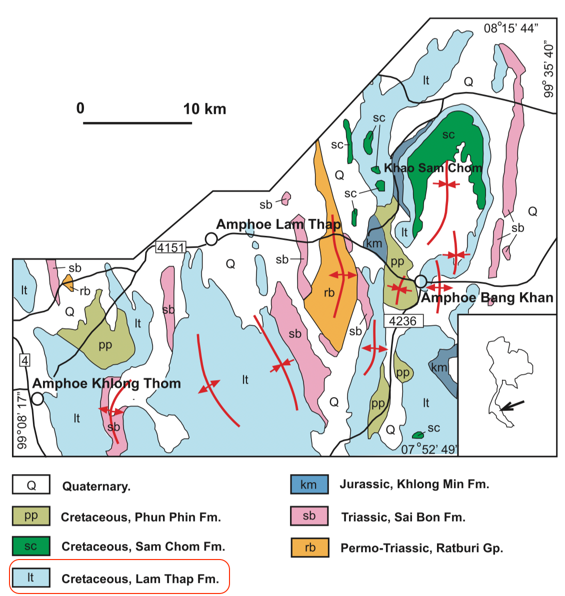
At Khao Tao between Km 22 and Km 25 of road no 4110 (Thung Yai to Thung Song), Nakhon Si Thammarat; Named after Lam Thap district of Nakhon Si Thammarat; reference section at Laem Pleo of Bo Muang village, Krabi province. Proposed by Raksaskulwong and others (1990), revised by Teerarungsigul and others (1999), Raksaskulwong (2002). Parent unit: Thung Yai Gr (Trang Group).
Synonym: หมวดหินลําทับ
[Figure: Geological map of the Thung Yai Gr in Khlong Thom-Bang Khan area, Peninsular Thailand (Meesook, 2011)]
Lithology and Thickness
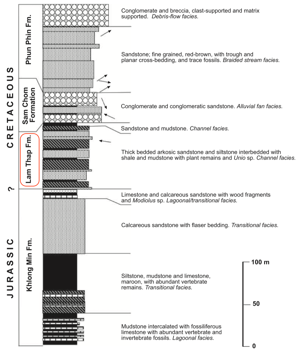
Thick bedded arkosic sandstone, and siltstone interbedded with shale and mudstone with plant remains and Unio sp. Raksaskulwong (2002) reported several fining upward cycles of "two alternating lithofacies: predominantly arkosic sandstone, and predominantly sandstone, siltstone and mudstone. In some areas, the formation is made up almost entirely of thick-bedded arkosic sandstone. Elsewhere it is siltstone and mudstone interbedded with sand- stone and conglomeratic sandstone with common fining- and. Thickness: 30 m at Laem Pleo, 197 m at Khao Tao.
[Figure: Generalized lithological column of the Thung Yai Gr in southern Peninsular Thailand (modified after Teerarungsigul et al. 1999). The upper three formations are Cretaceous while the lowest, the Khlong Min Fm, is Jurassic. Arrows indicate current directions determined from cross-bedding. (Meesook, 2011)]
Lithology Pattern:
Clayey sandstone
Relationships and Distribution
Lower contact
Khlong Min Fm (conformable) of Jurassic
Upper contact
Sam Chom Fm (conformable)
Regional extent
Lower Peninsula: Nakhon Si Thammarat, Krabi, and Trang provinces. Correlation: Sao Khua Fm. Lateral facies changes are very common. This facies crops out mainly in Khao Tao, Khao Yan Yao, Khao Chong Din and Khao Khiam. It is thought by Raksaskulwong (1994) to correlate with and be synonymous with the Chumphon Redbeds Fm.
GeoJSON
{"type":"Feature","geometry":{"type":"MultiPolygon","coordinates":[[[[99.37,9.2],[99.66,9.37],[99.89,9.32],[100.16,8.78],[100.39,7.93],[100.58,6.98],[100.57,6.39],[100.32,6.3],[99.81,6.7],[99.24,7.45],[98.82,8.18],[99.08,8.51],[99.37,9.2]]]]}}
Age
Early Cretaceous; but extent is uncertain
Age Span:
Beginning stage:
Berriasian
Fraction up in beginning stage:
0
Beginning date (Ma):
145.73
Ending stage:
Barremian
Fraction up in the ending stage:
1.0
Ending date (Ma):
126.30
Depositional setting
Fluviatile (meandering river) with channel sands.
Depositional pattern:
Additional Information
Compiler:
Wen Du - modified from Lexicon of Stratigraphic Names of Thailand of 2013; Assanee Meesook, 2011, Chapter 8 Cretaceous in Ridd, M.F., Barber, A.J., and Grow, M.J., editors, The Geology of Thailand, Geol. Soc. of London.